
")
 (Read more...)")
")
")
")
")
")
")
")
")
Newsletters
Subscribe to our newsletter and get statistical data as soon as it is available!...
DREM updates the Time Series of Meteorological Information with data from 2021
The Regional Directorate of Statistics of Madeira (DREM) updates today on its website the "Time Series of Meteorological Information" with data from 2021, provided by the Portuguese Institute of Sea and Atmosphere I.P. (IPMA I.P.) to Statistics Portugal (INE), through its Regional Delegation. Also, for the first time, a Dashboard summarizing the main meteorological information for 2021 is made available on the DREM website. The new meteorological Dashboard uses visually appealing graphics and infographics and allows the selection of different indicators according to the weather stations in the Autonomous Region of Madeira (ARM).
Air temperature - 2021 was not as warm as 2020 in most stations
In most weather stations of the Autonomous Region of Madeira, the average annual temperature decreased compared to 2020. At Caniçal/Ponta de São Lourenço, Porto Moniz, Santana and Porto Santo/Airport stations, the average annual temperature remained the same, while at Ponta do Pargo it increased.
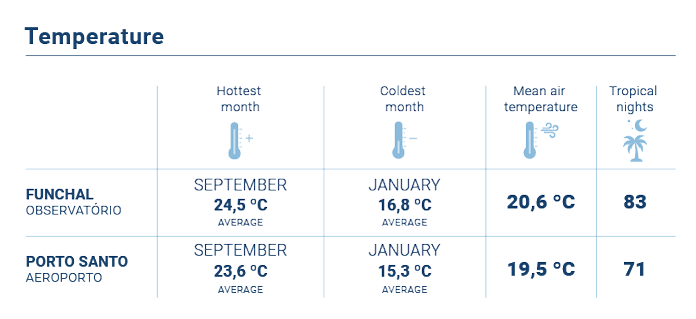
In the last 46 years, at the Funchal/Observatory station, the average annual temperatures ranged between 18.1 °C in 1976 and 1984 and 20.8 °C, a value recorded in 2020, the warmest year in this station since records exist. Compared to 2020 the average annual temperature at this station, in 2021 decreased by 0.2 °C (20.6 ºC). Despite the slight decrease, the last 3 years, along with 2004, were the warmest ever at the station of Funchal/Observatory.
Compared with the climatological normal 1961-1990 (average value of the reference period for air temperature), in 2021, all stations for which it is possible to obtain this information (8 stations) show higher values, mainly in the Funchal/Observatory with +1.9 ºC of deviation from the normal of that station, followed by the Santo da Serra station (+1.8 ºC), Chão do Areeiro (+1.5 ºC), Lugar de Baixo and Bica da Cana (both with +1.3 ºC).
The highest average annual temperature was recorded at the Lido station (20.8 °C) and the lowest at Pico do Areeiro (10.2 °C). With regard to maximum and minimum air temperatures in the last year, the extremes occurred at the stations of Prazeres (36.7 °C in August) and Pico do Areeiro (-2.7 °C in January and February).
August was the warmest month in 2021 at 11 of the 21 operational meteorological stations in the Autonomous Region of Madeira (excluding the Selvagens station, due to the absence of data in 2021), with monthly average temperatures ranging from 24.1 °C at the Santa Catarina/Airport station to 18.4 °C recorded at the Achadas da Cruz station. In contrast, January was the coldest month in 18 stations, with monthly average values between 5.9 °C at Pico do Areeiro and 17.5 °C at Funchal/Lido.
Precipitation - 2021 was rainier than 2020
In 2021, most stations for which there are precipitation records for the last two years, recorded precipitation values higher than in 2020, with emphasis on the Funchal/Observatory station, where the increase in total precipitation was higher: 503.5 mm in 2020 and 861.8 mm in 2021.
However, when comparing with the climatological normal 1961-1990 shows that the values recorded in 2021, in general, were much lower than this reference, highlighting the stations of Chão do Areeiro and Bica da Cana, with negative values in the order of 1 251.1 mm and 1 169.3 mm, respectively. The Funchal/Observatory, Porto Santo /Airport and Santa Catarina/Airport were the only stations to record positive deviations from normal (220.6 mm, 133.5 mm and 15.2 mm, respectively).
In 2021, the highest values of annual precipitation occurred in weather stations of Pico do Areeiro (2 017.0 mm), Bica da Cana (1 797.2 mm), Chão do Areeiro (1 688.2 mm) and São Vicente (1 377.9 mm). On the contrary, the lowest values occurred in Funchal/Lido (469.2 mm), Caniçal/Ponta de São Lourenço (508.6 mm) and Porto Santo/Airport (519.9 mm).
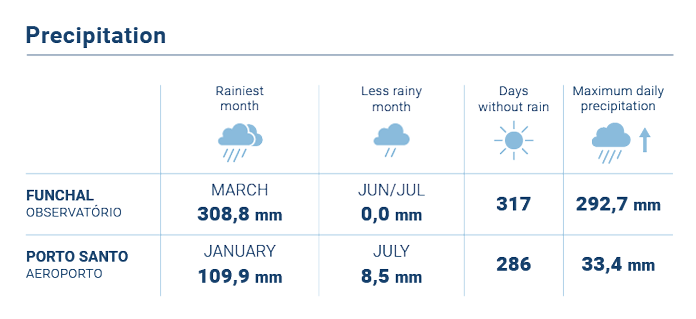
January was the rainiest month in most of the stations, having been in Pico do Areeiro where it was observed the highest precipitation value (531.0 mm) that month, and in Porto Santo/Airport station the lowest value (109.9 mm).
July was, in general, the month that registered less precipitation, with values varying between 0.0 mm at Quinta Grande, Chão do Areeiro, Pico do Areeiro, Funchal/Lido, Funchal/Observatory, Cancela/SRPC stations and 26.2 mm at Santo da Serra station.
Analysing the days by the amount of precipitation (rainy, very rainy and extremely rainy days), the data show that the maximum days with rain were recorded at Bica da Cana (130 days), and in the case of rainy days was also the Bica da Cana to record the highest value (51 days). Chão do Areeiro and Bica da Cana stood out both in the number of very rainy days (26 days) and the number of extremely rainy days (16 days).
In 2021, 320 dry days were recorded at the Funchal/Lido station, the maximum value in all weather stations, 7 days below the record of 2020. Note that in Funchal/Observatory and Chão do Areeiro, in the last 11 years, the number of days with rain (days with 1 mm of precipitation or more) has always been lower than 1961/1990 normal. The lowest number of dry days was observed in Bica da Cana (235 days, the same value as in 2020).
Relative Humidity of the air - 2021 was wetter in most stations
Of the stations that have annual average of relative humidity of the air, Ponta do Pargo, Caniçal/Ponta de São Lourenço, Lugar de Baixo, Santa Catarina, Santana and Ponta de São Jorge showed a lower value than in 2020. In the remaining stations, the relative humidity of the air increased or remained the same compared to 2020.
Analysing the last year, it is possible to verify that the average annual values of relative humidity of the air ranged between 66% in Pico do Areeiro, Quinta Grande, Funchal Observatory and Lugar de Baixo and 89% in Achadas da Cruz, and in this station, the average relative humidity of the air was higher than 2020 in 2%.
In the analysis of the information on a monthly scale, it is noteworthy that the minimum average value of relative humidity of the air (32%) was recorded at the station of Pico do Areeiro, in July and the maximum average value (97%) was observed at the station of Achadas da Cruz/Lombo da Terça in November.
Extreme events, wind and sea surface temperature - 2021 with more tropical nights, less wind and warmer seawater
With regard to tropical nights, i.e. in which the minimum temperature was equal to or higher than 20 °C, in 2021, most stations either increased or maintained the number of tropical nights. The Funchal/Lido station stood out with 117 days recorded, followed by the Porto Moniz station with 105 days, Funchal/Observatory with 99 days and Lugar de Baixo with 97 days. Relatively to 1961-1990 normal, all stations registered more tropical nights mainly Santa Catarina/Airport (+41 nights), Porto Santo/Airport (+33 nights), Lugar de Baixo (+29 nights) and Funchal/Observatory (+16 nights).
In 2021, the highest average daily temperature range (difference between the maximum and minimum temperature) occurred at Bica da Cana station (9,2 °C), which was the highest value registered in the series 2000-2021. The lowest difference between the maximum and minimum daily temperatures in 2021, was observed at the Ponta de São Lourenço station (4.2 °C).
In 2021, the annual average wind intensity decreased or remained the same at most stations with an anemometer (16 stations). Achadas/Lombo da Terça was the station with the highest annual average (27.1 km/h), while Monte/Quinta Jardins do Imperador had the lowest average (3.9 km/h).
The strongest wind gust was recorded in Chão do Areeiro (145 km/h) in December.
In 2021, the average annual sea water temperature measured in Pontinha (Funchal) was 20.8 °C, -0.2 °C than in the year 2020. The average of September was the highest (23.8 °C) and April the lowest (18.8 °C).
For more information, please click on:
International Statistical Cooperation
 |
International Statistical Cooperation
|
Statistical Literacy
 |
Statistical Literacy
|
|
|
|
|
|
|

Copyright © 2026 Direção Regional de Estatística da Madeira. All rights reserved.
Address: Calçada de Santa Clara 38, 9004-545 Funchal, Madeira Island
Phone: +351 291 145 126 (National landline call)