
- HomeHome
- DREMDREM
-
Statistical InformationStatistical Information
-
Economic
- Government
- Agriculture, Forestry and Fishing
- Construction and housing
- Trade
- Economic Accounts
- Enterprises
- Industry and energy
- Innovation and knowledge
- Prices
- Monetary and Financial Sector
- Short-term trends
- Transports and Communications
- Tourism
-
Social
- Culture, Sport and Recreation
- Education
- Health
- Justice
- Labour market
- Population and Social Standards
- Social protection
- Territory
- Multithemes
- Indicators System
-
Economic
- Dissemination CalendarDissemination Calendar
- MetadataMetadata
- LinksLinks
- Site MapSite Map
- Press release
- Dashboards
- Contact usContact us
- RAMStats 2.0
")
 (Read more...)")
")
")
")
")
")
")
")
")
Notícias (GB)
DREM releases updated Time Series on Communications with 2025 data (Read more...)
DREM releases the final results of the 2025 Tourism Statistics and updates the corresponding Time Series (1976-2025) (Read more...)
In 2025, the main obstacles to reconciling work and family life were long working hours and unpredictable or atypical working hours (Read more...)
In 2025, the number of inoculations administered in the Region increased by 2.5% (Read more...)
In June 2026, the Confidence Indicator in Manufacturing Industry and Services increased, while in Construction and Public Works and in Trade there was a decrease (Read more...)
DREM publishes a new edition of the Quarterly Statistical Bulletin covering the 1st quarter of 2026 (Read more...)
In May 2026, the passenger movement at the airports of the Autonomous Region of Madeira recorded a year-on-year growth of 5.5% (Read more...)
In the 1st quarter of 2026, the median rent for new lease agreements increased by 16.0% and the number of new agreements fell by 8.6% year-on-year (Read more...)
In 2024/2025, the 2nd cycle of Primary Education recorded the highest progression/completion rate (Read more...)
In May 2026, the median value of bank appraisals for housing in the Autonomous Region of Madeira stood at 2 598 euros per square metre (Read more...)
Newsletters
Subscribe to our newsletter and get statistical data as soon as it is available!...
DREM updates Territory Statistics
The Regional Directorate of Statistics of Madeira (DREM) releases today on its website, a set of tables with updated information regarding territory, namely data concerning areas, perimeters, and altimetry of the revised and updated version of the Official Administrative Map of Portugal, 2021 version - CAOP2021 whose responsibility in the Autonomous Region of Madeira belongs to the Regional Directorate for Spatial Planning (DROTe).
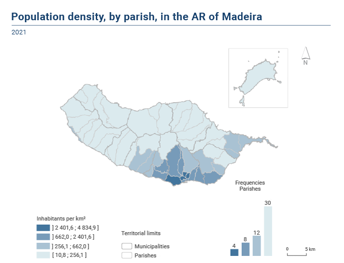
Information is also provided on the resident population at the civil parish level (final data from the 2021 Census), its population density, data on the territorial structure, extreme points, and major mountain systems.
In 2021, the population density in the Autonomous Region of Madeira stood at 313.0 inhabitants per km2
In 2021, the population density in the Autonomous Region of Madeira stood at 313.0 inhabitants per km2, with the highest value in Funchal (1,387.7 inhabitants/km2) and the lowest in Porto Moniz (30.4 inhabitants/km2). By parish, this indicator reaches its highest value in S. Pedro (4 834.9 inhabitants/km2) and its lowest value in Ribeira da Janela (10.8 inhabitants/km2).
Compared to the other six NUTS II regions in Portugal, the Autonomous Region of Madeira has the second highest population density, only behind Área Metropolitana de Lisboa (951.9 inhabitants/km2). Alentejo is the region with the lowest population density (22.3 inhabitants/km2), while the Autonomous Region of Azores has a population density of 101.8 inhabitants/km2.
International Statistical Cooperation
 |
International Statistical Cooperation
|
Statistical Literacy
 |
Statistical Literacy
|
|
|
|
|

|
|

Copyright © 2026 Direção Regional de Estatística da Madeira. All rights reserved.
Address: Calçada de Santa Clara 38, 9004-545 Funchal, Madeira Island
Phone: +351 291 145 126 (National landline call)